Property Record
406 Pleasant Hill Rd Nw, Lilburn, GA 30047


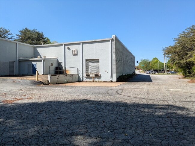
This Property Is For Sale
Current Lease Availabilities
NEARBY LISTINGS FOR SALE OR LEASE
Property Detail
406 Pleasant Hill Rd Nw
Atlanta-Sandy Springs-Roswell, GA
Pleasant Hill
6-151-004
PLEASANT HILL
Autorepair
Gwinnett
X
Georgia
13135C0100F
151
0
1.26 AC
2025
Gwinnett Mall/Duluth
050441
Atlanta
11,052 SF
DEMOGRAPHICS near 406 Pleasant Hill Rd Nw
1 Mile
3 Mile
5 Mile
2024 Total Population
10,326
98,283
260,177
2029 Population
10,610
102,332
270,619
Pop Growth 2024-2029
+ 2.75%
+ 4.12%
+ 4.01%
Average Age
35
36
36
2024 Total Households
3,264
32,088
86,398
HH Growth 2024-2029
+ 2.39%
+ 4.16%
+ 4.08%
Median Household Inc
$50,915
$57,451
$61,912
Avg Household Size
3.00
3.00
2.90
2024 Avg HH Vehicles
2.00
2.00
2.00
Median Home Value
$255,395
$265,889
$273,242
Median Year Built
1990
1989
1990
Nearby Places
Map Layers
Map Styles
 Street
 Aerial
- Restaurants
- Banks
- Shops
- Fitness
- Groceries
PUBLIC TRANSPORTATION
AIRPORT
Hartsfield - Jackson Atlanta International
DRIVE
WALK
Distance
Hartsfield - Jackson Atlanta International
49 min
32.8 mi
Nearby Properties
Address
Land Use
TOTAL SIZE
Lot Size
Zoning
Address
Land Use
TOTAL SIZE
Lot Size
Zoning
338,670 SF
28.61 AC
RM
Address
Land Use
TOTAL SIZE
Lot Size
Zoning
357,946 SF
30.92 AC
RM
Address
Land Use
TOTAL SIZE
Lot Size
Zoning
444,605 SF
37.43 AC
RM
Address
Land Use
TOTAL SIZE
Lot Size
Zoning
348,681 SF
35.52 AC
RM10
Address
Land Use
TOTAL SIZE
Lot Size
Zoning
440,998 SF
35.04 AC
RM
Address
Land Use
TOTAL SIZE
Lot Size
Zoning
464,756 SF
33.96 AC
RM13
Address
Land Use
TOTAL SIZE
Lot Size
Zoning
419,855 SF
29.83 AC
RM13
Address
Land Use
TOTAL SIZE
Lot Size
Zoning
483,912 SF
43.10 AC
OI
Address
Land Use
TOTAL SIZE
Lot Size
Zoning
470,856 SF
34.99 AC
RM13
Address
Land Use
TOTAL SIZE
Lot Size
Zoning
265,226 SF
18.05 AC
RM
Address
Land Use
TOTAL SIZE
Lot Size
Zoning
336,554 SF
30.40 AC
RM
Address
Land Use
TOTAL SIZE
Lot Size
Zoning
412,644 SF
23.17 AC
RM
Address
Land Use
TOTAL SIZE
Lot Size
Zoning
313,246 SF
17.15 AC
RM13
Address
Land Use
TOTAL SIZE
Lot Size
Zoning
455,471 SF
48.23 AC
R75
Address
Land Use
TOTAL SIZE
Lot Size
Zoning
364,994 SF
34.06 AC
RM13
Address
Land Use
TOTAL SIZE
Lot Size
Zoning
331,159 SF
35.49 AC
RM8
Address
Land Use
TOTAL SIZE
Lot Size
Zoning
420,759 SF
33.62 AC
RM13
Address
Land Use
TOTAL SIZE
Lot Size
Zoning
285,384 SF
21.32 AC
RM
Address
Land Use
TOTAL SIZE
Lot Size
Zoning
371,383 SF
29.56 AC
RM13
Address
Land Use
TOTAL SIZE
Lot Size
Zoning
287,502 SF
43.15 AC
R1
Address
Land Use
TOTAL SIZE
Lot Size
Zoning
236,654 SF
9.53 AC
RM24
Address
Land Use
TOTAL SIZE
Lot Size
Zoning
306,330 SF
26.20 AC
RM
Address
Land Use
TOTAL SIZE
Lot Size
Zoning
283,958 SF
23.75 AC
RM13
Address
Land Use
TOTAL SIZE
Lot Size
Zoning
225,939 SF
19.79 AC
RM13
Address
Land Use
TOTAL SIZE
Lot Size
Zoning
517,654 SF
28.39 AC
RM
Address
Land Use
TOTAL SIZE
Lot Size
Zoning
290,652 SF
35.67 AC
RM8
Address
Land Use
TOTAL SIZE
Lot Size
Zoning
244,131 SF
32.59 AC
RM8
Address
Land Use
TOTAL SIZE
Lot Size
Zoning
280,313 SF
20.36 AC
RM13
Address
Land Use
TOTAL SIZE
Lot Size
Zoning
365,415 SF
8.80 AC
OI
Address
Land Use
TOTAL SIZE
Lot Size
Zoning
228,602 SF
29.16 AC
C2
The World's #1 Commercial Real Estate Marketplace
Connect with us
© 2025 CoStar Group
The information above has been obtained from sources believed reliable. While we do not doubt its accuracy we have not verified it and make no guarantee, warranty or representation about it. It is your responsibility to independently confirm its accuracy and completeness. Any projections, opinions, assumptions, or estimates used are for example only and do not represent the current or future performance of the property. The value of this transaction to you depends on tax and other factors which should be evaluated by your tax, financial, and legal advisors. You and your advisors should conduct a careful, independent investigation of the property to determine to your satisfaction the suitability of the property for your needs.